

 购买(
购买( 试用
试用
 使用 HBuilderX 导入示例项目
 赞赏(0)
赞赏(0)
更新记录
1.0.0(2023-03-22)
新版首发
平台兼容性
| Android | Android CPU类型 | iOS |
|---|---|---|
| 适用版本区间:4.4 - 12.0 | armeabi-v7a:支持,arm64-v8a:支持,x86:支持 | 适用版本区间:11 - 16 |
原生插件通用使用流程:
- 购买插件,选择该插件绑定的项目。
- 在HBuilderX里找到项目,在manifest的app原生插件配置中勾选模块,如需要填写参数则参考插件作者的文档添加。
- 根据插件作者的提供的文档开发代码,在代码中引用插件,调用插件功能。
- 打包自定义基座,选择插件,得到自定义基座,然后运行时选择自定义基座,进行log输出测试。
- 开发完毕后正式云打包
付费原生插件目前不支持离线打包。
Android 离线打包原生插件另见文档 https://nativesupport.dcloud.net.cn/NativePlugin/offline_package/android
iOS 离线打包原生插件另见文档 https://nativesupport.dcloud.net.cn/NativePlugin/offline_package/ios
注意事项:使用HBuilderX2.7.14以下版本,如果同一插件且同一appid下购买并绑定了多个包名,提交云打包界面提示包名绑定不一致时,需要在HBuilderX项目中manifest.json->“App原生插件配置”->”云端插件“列表中删除该插件重新选择
KJ-GeoFence
高德地图定位扩展、地理围栏、电子围栏
注意事项
1.manifest.json -> app模块配置 -> 定位 -> 高德地图 勾选  配置正确key
2.manifest.json -> app模块配置 -> Maps -> 高德地图 勾选  配置正确key
3.需要定位权限
4.需要精确位置
5.ios需要后台定位,需要配置manifest.json->App常用其它设置->后台运行能力 location
使用
<template>
<view class="content">
<map style="width: 0;height: 0;">注意:需要放置map,执行配置key和隐私政策</map>
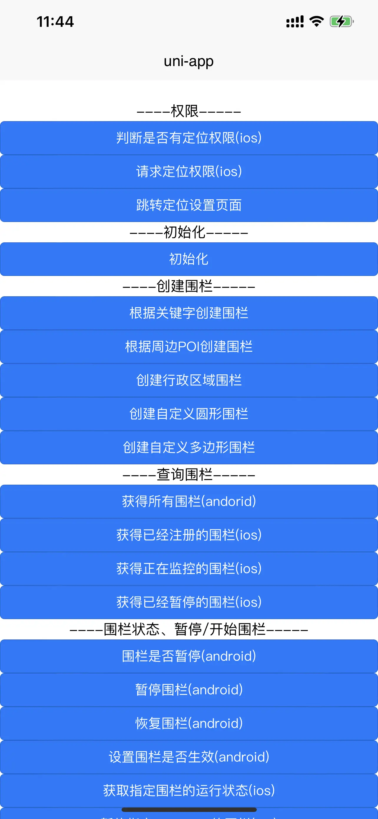
<view class="title">----权限-----</view>
<button type="primary" @click="judgePermission">判断是否有定位权限(ios)</button>
<button type="primary" @click="requestPermission">请求定位权限(ios)</button>
<button type="primary" @click="gotoLocationSetting">跳转定位设置页面</button>
<view class="title">----初始化-----</view>
<button type="primary" @click="init">初始化</button>
<view class="title">----创建围栏-----</view>
<button type="primary" @click="addKeywordPOIRegion">根据关键字创建围栏</button>
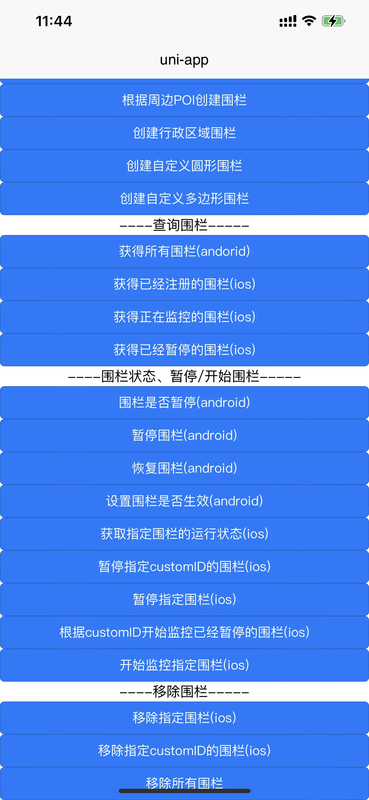
<button type="primary" @click="addAroundPOIRegion">根据周边POI创建围栏</button>
<button type="primary" @click="addDistrictRegion">创建行政区域围栏</button>
<button type="primary" @click="addCircleRegion">创建自定义圆形围栏</button>
<button type="primary" @click="addPolygonRegion">创建自定义多边形围栏</button>
<view class="title">----查询围栏-----</view>
<button type="primary" @click="getAllGeoFence">获得所有围栏(andorid)</button>
<button type="primary" @click="getGeoFenceRegions">获得已经注册的围栏(ios)</button>
<button type="primary" @click="getMonitoringGeoFenceRegions">获得正在监控的围栏(ios)</button>
<button type="primary" @click="getPausedGeoFenceRegions">获得已经暂停的围栏(ios)</button>
<view class="title">----围栏状态、暂停/开始围栏-----</view>
<button type="primary" @click="isPause">围栏是否暂停(android)</button>
<button type="primary" @click="pauseGeoFence">暂停围栏(android)</button>
<button type="primary" @click="resumeGeoFence">恢复围栏(android)</button>
<button type="primary" @click="setGeoFenceAble">设置围栏是否生效(android)</button>
<button type="primary" @click="getGeoFenceRegionStatus">获取指定围栏的运行状态(ios)</button>
<button type="primary" @click="pauseGeoFenceRegions">暂停指定customID的围栏(ios)</button>
<button type="primary" @click="pauseTheGeoFenceRegion">暂停指定围栏(ios)</button>
<button type="primary" @click="startGeoFenceRegions">根据customID开始监控已经暂停的围栏(ios)</button>
<button type="primary" @click="startTheGeoFenceRegion">开始监控指定围栏(ios)</button>
<view class="title">----移除围栏-----</view>
<button type="primary" @click="removeTheGeoFenceRegion">移除指定围栏(ios)</button>
<button type="primary" @click="removeGeoFenceRegions">移除指定customID的围栏(ios)</button>
<button type="primary" @click="removeAllGeoFenceRegions">移除所有围栏</button>
</view>
</template>
<script>
const KJGeoFence = uni.requireNativePlugin('KJ-GeoFence');
export default {
data() {
return {
title: 'Hello'
}
},
onLoad() {
if (plus.os.name == 'Android') {
plus.android.requestPermissions(
['android.permission.ACCESS_FINE_LOCATION',
'android.permission.ACCESS_COARSE_LOCATION'
],
function(resultObj) {
var result = 0;
for (var i = 0; i < resultObj.granted.length; i++) {
var grantedPermission = resultObj.granted[i];
console.log('已获取的权限:' + grantedPermission);
result = 1
}
for (var i = 0; i < resultObj.deniedPresent.length; i++) {
var deniedPresentPermission = resultObj.deniedPresent[i];
console.log('拒绝本次申请的权限:' + deniedPresentPermission);
result = 0
}
for (var i = 0; i < resultObj.deniedAlways.length; i++) {
var deniedAlwaysPermission = resultObj.deniedAlways[i];
console.log('永久拒绝申请的权限:' + deniedAlwaysPermission);
result = -1
}
},
function(error) {
console.log('申请权限错误:' + error.code + " = " + error.message);
}
);
}
var globalEvent = uni.requireNativePlugin('globalEvent');
globalEvent.addEventListener('geoFenceCallBack', function(res) {
console.log('geoFenceCallBack' + JSON.stringify(res));
if (res.method == "onGeoFenceCreateFinished") {
console.log("添加地理围栏完成")
/**
* 返回json字段说明:
* customID - 用户自定义ID
* ios:
* {"method":"onGeoFenceCreateFinished","customID":"poi_1","regions":[{"currentLocation":{"longitude":0,"latitude":0},
* "regionType":2,"customID":"poi_1","identifier":"A1816549-BDF8-4F12-BF2E-0AEC3A05CF09","
* poiRegion":{"POIItem":{"address":"广州塔","location":{"longitude":113.324553,"latitude":23.106414},"typeCode":[],"city":[],"district":[],"tel":[],
* "type":[],"name":"广东省广州市海珠区广州塔","province":[]}},"fenceStatus":0}],"error":null}
* regions - 地理围栏信息
* regionType - 地理围栏类型 0(圆形地理围栏) 1(多边形地理围栏) 2(兴趣点(POI)地理围栏) 3(行政区划地理围栏)
* identifier - 唯一标识符
* fenceStatus - 用户的位置和围栏的关系 0(未知) 1(进入围栏) 2(离开围栏) 3(停留在地理围栏内10分钟)
* poiRegion - poi围栏相关信息
* circleRegion - 圆形围栏相关信息
* polygonRegion - 多边形围栏相关信息
* districtRegion - 行政区围栏相关信息
* andoird:
* {"customID":"poi_1","errorCode":0,"geoFenceList":[{"fenceId":"346913142","customId":"poi_1","status":0,
* "pointList":[[{"longitude":113.324553,"latitude":23.106414}]],"activatesAction":7,"center":{"longitude":113.324553,
* "latitude":23.106414},"type":2,"isAble":true,"poiItem":{"typeCode":"[]","poiId":"","tel":"[]","latitude":23.106414,
* "longitude":113.324553,"poiName":"广东省广州市海珠区广州塔","province":"[]","poiType":"[]","address":"广州塔","adname":"[]","city":"[]"}}],
* "method":"onGeoFenceCreateFinished"}
* errorCode - 错误码
*
* geoFenceList - 地理围栏信息
* fenceId - 地理围栏的ID
* status - 围栏的状态 0(未知) 1(进入围栏) 2(离开围栏) 4(停留在地理围栏内10分钟)
* pointList - 围栏坐标点
* activatesAction - 地理围栏触发条件
* center - 围栏中心点坐标
* type - 地理围栏类型 0(圆形地理围栏) 1(多边形地理围栏) 2(兴趣点(POI)地理围栏) 3(行政区划地理围栏)
* isAble - 围栏是否可用
* */
} else if (res.method == "onGeoFencesStatusChanged") {
console.log("地理围栏状态改变")
/**
* 返回json字段说明:
* customID - 用户自定义ID
* ios:
* {"error":null,"method":"onGeoFencesStatusChanged","region":{"currentLocation":{"longitude":113.2867982313368,
* "latitude":23.074051920572916},"regionType":2,"customID":"poi_1","identifier":"CA9025BA-0E16-48E5-A7CB-ECDC0ACE9F18",
* "poiRegion":{"POIItem":{"address":"广州塔","location":{"longitude":113.324553,"latitude":23.106414},"typeCode":[],"city":[],
* "district":[],"tel":[],"type":[],"name":"广东省广州市海珠区广州塔","province":[]}},"fenceStatus":2}}
* region - 地理围栏信息
* regionType - 地理围栏类型 0(圆形地理围栏) 1(多边形地理围栏) 2(兴趣点(POI)地理围栏) 3(行政区划地理围栏)
* identifier - 唯一标识符
* fenceStatus - 用户的位置和围栏的关系 0(未知) 1(进入围栏) 2(离开围栏) 3(停留在地理围栏内10分钟)
* poiRegion - poi围栏相关信息
* circleRegion - 圆形围栏相关信息
* polygonRegion - 多边形围栏相关信息
* districtRegion - 行政区围栏相关信息
* andoird:
* {"status":2,"customID":"poi_1","fenceID":"348069906","method":"onGeoFencesStatusChanged","geoFence":
* {"fenceId":"348069906","customId":"poi_1","status":2,"pointList":[[{"longitude":113.324553,"latitude":23.106414}]],
* "activatesAction":7,"center":{"longitude":113.324553,"latitude":23.106414},"type":2,"isAble":true,"poiItem":{"typeCode":"[]",
* "poiId":"","tel":"[]","latitude":23.106414,"longitude":113.324553,"poiName":"广东省广州市海珠区广州塔","province":"[]","poiType":"[]",
* "address":"广州塔","adname":"[]","city":"[]"}}}
*
* errorCode - 错误码 0(创建地理围栏成功) 1(参数错误) 4(网络连接异常) 5(解析数据失败(有可能是连接的需要登录的网络但是没有登录))
* 7(鉴权失败) 8(其他未知错误) 16(无可用地理围栏)
* 17(相同的围栏已经存在,无需重复添加 当地理围栏的customID,半径,周边点(多边形),中心点坐标(圆形)这几个属性完全一致时,则认为是相同围栏)
*
* geoFence - 地理围栏信息
* fenceId - 地理围栏的ID
* status - 围栏的状态 0(未知) 1(进入围栏) 2(离开围栏) 4(停留在地理围栏内10分钟)
* pointList - 围栏坐标点
* activatesAction - 地理围栏触发条件
* center - 围栏中心点坐标
* type - 地理围栏类型 0(圆形地理围栏) 1(多边形地理围栏) 2(兴趣点(POI)地理围栏) 3(行政区划地理围栏)
* isAble - 围栏是否可用
* */
}
});
this.init();
},
methods: {
judgePermission() {
KJGeoFence.judgePermission((res) => {
console.log("judgePermission:" + JSON.stringify(res));
/**
* 返回json字段说明:{"result":true,"status":3}
* result:是否授权
* status:0-还没决定 1-受限制 2-拒绝 3、4、5-已授权
* */
})
},
requestPermission() {
KJGeoFence.requestPermission()
},
gotoLocationSetting() {
KJGeoFence.gotoLocationSetting();
},
init() {
/**
* activeAction - 地理围栏监听状态
* andorid:1(进入围栏) 2(离开围栏) 4(停留在地理围栏内10分钟)
* ios:1 << 0(进入围栏) 1 << 1(离开围栏) 1 << 2(停留在地理围栏内10分钟)
* */
var dic;
if (plus.os.name == 'Android') {
dic = {
"activeAction": 1 | 2 | 4
};
} else {
dic = {
"pausesLocationUpdatesAutomatically": false, //ios才有效,定位是否会被系统自动暂停
"allowsBackgroundLocationUpdates": false, //ios才有效,//是否开启后台定位,为true 需要配置manifest.json->App常用其它设置->后台运行能力 location
"detectRiskOfFakeLocation": true, //ios才有效,检测是否存在虚拟定位风险
"activeAction": 1 << 0 | 1 << 1 | 1 << 2
};
}
KJGeoFence.init(dic, (res) => {
console.log("init:" + JSON.stringify(res));
})
},
addKeywordPOIRegion() {
var dic = {
"keyword": "广州塔", //POI关键字
"poiType": "景区", //POI类型
"city": "广州市", //POI所在的城市名称
"size": 20, //要查询的数据的条数 0-25
"customID": "poi_1" //用户自定义ID
};
KJGeoFence.addKeywordPOIRegion(dic, (res) => {
console.log("addKeywordPOIRegion:" + JSON.stringify(res));
})
},
addAroundPOIRegion() {
var dic = {
"locationPoint": { //周边区域中心点的经纬度,以此中心点建立周边地理围栏
"latitude": 23.176514,
"longitude": 113.238836,
},
"aroundRadius": 3000, //周边半径,0-50000米,这个是搜索半径,不是建立的围栏的半径
"keyword": "广州塔", //POI关键字
"poiType": "景区", //POI类型
"city": "广州市", //POI所在的城市名称
"size": 20, //要查询的数据的条数 0-25
"customID": "poi_2" //用户自定义ID
};
KJGeoFence.addAroundPOIRegion(dic, (res) => {
console.log("addAroundPOIRegion:" + JSON.stringify(res));
})
},
addDistrictRegion() {
var dic = {
"districtName": "海珠区", //区域名称
"customID": "district_1" //用户自定义ID
};
KJGeoFence.addDistrictRegion(dic, (res) => {
console.log("addDistrictRegion:" + JSON.stringify(res));
})
},
addCircleRegion() {
var dic = {
"center": { //围栏中心点的经纬度
"latitude": 23.176514,
"longitude": 113.238836,
},
"radius": 300, //创建的围栏的半径,半径大于0,单位米
"customID": "circle_1" //用户自定义ID
};
KJGeoFence.addCircleRegion(dic, (res) => {
console.log("addCircleRegion:" + JSON.stringify(res));
})
},
addPolygonRegion() {
var dic = {
"coordinates": [{ //经纬度坐标点数据,最少3个点
"latitude": 23.237925,
"longitude": 113.177899,
}, {
"latitude": 23.236965,
"longitude": 113.175231,
}, {
"latitude": 23.239583,
"longitude": 113.174876,
}, {
"latitude": 23.240462,
"longitude": 113.17746,
}],
"customID": "polygon_1" //用户自定义ID
};
KJGeoFence.addPolygonRegion(dic, (res) => {
console.log("addPolygonRegion:" + JSON.stringify(res));
})
},
getAllGeoFence() {
KJGeoFence.getAllGeoFence((res) => {
console.log("getAllGeoFence:" + JSON.stringify(res));
})
},
getGeoFenceRegions() {
var dic = {
"customID": null //用户自定义ID,为null查询所有
};
KJGeoFence.getGeoFenceRegions(dic, (res) => {
console.log("getGeoFenceRegions:" + JSON.stringify(res));
})
},
getMonitoringGeoFenceRegions() {
var dic = {
"customID": null //用户自定义ID,为null查询所有
};
KJGeoFence.getMonitoringGeoFenceRegions(dic, (res) => {
console.log("getMonitoringGeoFenceRegions:" + JSON.stringify(res));
})
},
getPausedGeoFenceRegions() {
var dic = {
"customID": null //用户自定义ID,为null查询所有
};
KJGeoFence.getPausedGeoFenceRegions(dic, (res) => {
console.log("getPausedGeoFenceRegions:" + JSON.stringify(res));
})
},
isPause() {
KJGeoFence.isPause((res) => {
console.log("isPause:" + JSON.stringify(res));
})
},
pauseGeoFence() {
KJGeoFence.pauseGeoFence((res) => {
console.log("pauseGeoFence:" + JSON.stringify(res));
})
},
resumeGeoFence() {
KJGeoFence.resumeGeoFence((res) => {
console.log("resumeGeoFence:" + JSON.stringify(res));
})
},
resumeGeoFence() {
KJGeoFence.resumeGeoFence((res) => {
console.log("resumeGeoFence:" + JSON.stringify(res));
})
},
setGeoFenceAble() {
var dic = {
"fenceId": "", //地理围栏的fenceId
"able": false
};
KJGeoFence.getGeoFenceRegionStatus(dic, (res) => {
console.log("getGeoFenceRegionStatus:" + JSON.stringify(res));
})
},
getGeoFenceRegionStatus() {
var dic = {
"identifier": "" //用户自定义ID
};
KJGeoFence.getGeoFenceRegionStatus(dic, (res) => {
console.log("getGeoFenceRegionStatus:" + JSON.stringify(res));
})
},
pauseGeoFenceRegions() {
var dic = {
"customID": "polygon_1" //用户自定义ID
};
KJGeoFence.pauseGeoFenceRegions(dic, (res) => {
console.log("pauseGeoFenceRegions:" + JSON.stringify(res));
})
},
pauseTheGeoFenceRegion() {
var dic = {
"identifier": "" //唯一标识符
};
KJGeoFence.pauseGeoFenceRegions(dic, (res) => {
console.log("pauseGeoFenceRegions:" + JSON.stringify(res));
})
},
startGeoFenceRegions() {
var dic = {
"customID": "polygon_1" //用户自定义ID
};
KJGeoFence.startGeoFenceRegions(dic, (res) => {
console.log("startGeoFenceRegions:" + JSON.stringify(res));
})
},
startTheGeoFenceRegion() {
var dic = {
"identifier": "" //唯一标识符
};
KJGeoFence.startTheGeoFenceRegion(dic, (res) => {
console.log("startTheGeoFenceRegion:" + JSON.stringify(res));
})
},
removeTheGeoFenceRegion() {
var dic = {
"identifier": "" //唯一标识符
};
KJGeoFence.removeTheGeoFenceRegion(dic, (res) => {
console.log("removeTheGeoFenceRegion:" + JSON.stringify(res));
})
},
removeGeoFenceRegions() {
var dic = {
"customID": "poi_1" //用户自定义ID
};
KJGeoFence.removeGeoFenceRegions(dic, (res) => {
console.log("removeGeoFenceRegions:" + JSON.stringify(res));
})
},
removeAllGeoFenceRegions() {
KJGeoFence.removeAllGeoFenceRegions((res) => {
console.log("removeAllGeoFenceRegions:" + JSON.stringify(res));
})
}
}
}
</script>
<style>
button {
font-size: 15px;
}
.title {
text-align: center;
}
</style>
 下载 1323
 赞赏 10
赞赏 10

 下载 13372


 赞赏 1
赞赏 1


 赞赏
赞赏
 京公网安备:11010802035340号